

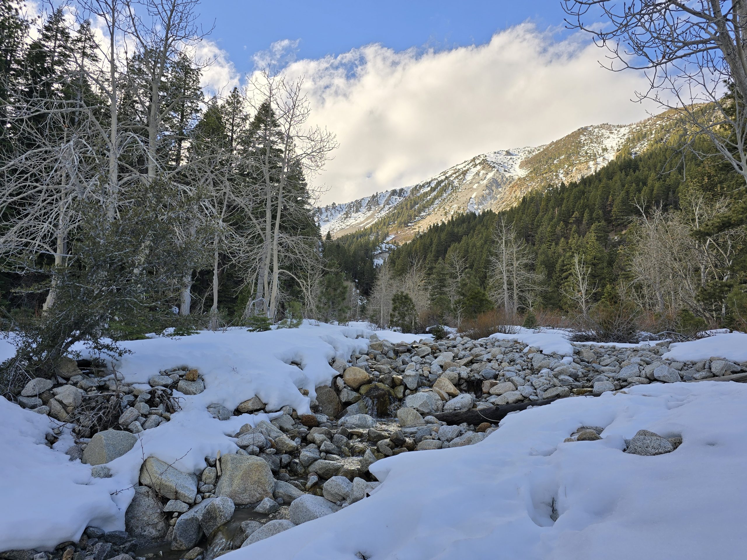
Well, God blessed us with an incredible hike today. Our friend Debra and her family are nearing the end of their full-time status in Tahoe and Debra wanted to fit in her favorite hike one last time. So, she invited us and a few others on a hike up through Shirley Canyon to High Camp at Squaw Valley – a little over a 3-mile hike with 1,959 feet of elevation gain. My husband and I have hiked this route several times since we’ve lived here, but never this early in the season. The creek and waterfalls were gushing and flowing everywhere, but that also means snow is still present and melting somewhere. Never mind that Squaw was still open for skiing this weekend.
Because of some of these unknowns, a few days ago, my husband and I referred to an online map of the trail vicinity that showed recent aerial photos taken that capture where the snow is. We wanted to have a better idea of what we’d be up against in terms of snow-related difficulty this weekend. From the map, we were pretty confident we could cross the rock face section and avoid the snow, but once we got up to Shirley Lake and headed up the final stretch to High Camp, we expected to come across plenty of snow, so then it would be a matter of how feasible the steepness was in relation to safely getting our footing in the snow.
In addition to all of that, we also knew that the forecast for today was predicting unsettled weather with a good chance of thunderstorms rolling into the area. When I looked at the forecast again this morning before we left, I saw that the storms could be rolling in as early as 10 AM. We got an early start this morning, figuring that the earlier we started, not only would we have a better chance of avoiding rain, but the snow would also be harder, which is easier to walk on than the wet and slippery melting kind.
Outside of the terrain, one of the unique aspects of this hike is that when you reach the top, you can ride the aerial tram back down to the bottom for free. While the ski resort was still operating, we thought it best that Debra confirmed prior to the hike that the tram would be available to us hikers today, which she did, and was told it would be.
All in all, on paper, it probably wasn’t the best day with the best conditions to tackle this particular hike, but we figured the worst thing that could happen (barring any injuries) is that we can only get so far on the trail and we end up having to turn back, or we get to High Camp and cannot ride the tram and end up having to hike the entire trail back down. Either way, we figured we’d give it a shot and see what happens. So that’s what we did.
Because of the early season, we saw water and waterfalls in places where we never have before on this hike, and the usual waterfalls were flowing the heaviest we’ve ever seen.


We’ve never seen this waterfall before.

A video from on top of the waterfall.
We made it to the mostly snowless rock face section and stopped for a beat to rest and have a quick snack before continuing on to Shirley Lake. Snacks with a view!

From here, the trail was a little harder to follow with all of the patches of snow, but we eventually arrived at Shirley Lake. When we hike up here during the summer, it isn’t uncommon for us to jump in for a swim or at least dunk in our lower legs. This time, however, the lake still had ice on it!


After a few minutes of taking photos, we had to make a decision as to whether the rest of the trail looked feasible (and safe) to continue up to High Camp. None of us had snowshoes with us. But since we’d already come at least two-thirds of the way, it seemed silly to turn around, unless we absolutely had to.
We headed toward the general direction of the snow-covered trail and started navigating our way up. We weaved around huge snow patches, through rock fields, and crossed mini-creeks flowing everywhere. Once we rounded the switchback, in front of us was ALL snow. Like, real, legitimate snow. Lucky for us, we had some packed-down snowmobile tracks to follow that made it a little easier to walk. It was getting close to 11 AM and the sun was really warm, which means the snow was getting more and more slippery.

Once we got to the bottom of the next hill, we had to turn a sharp left and start up the steepest section that would bring us up to the chairlift at the top and we’d be home free on our way to High Camp.

But that was no easy feat. The difficulty was reminiscent of the time we snowshoe hiked up to Incline Peak, only this time, we did not have snowshoes.

Rather than switch back, one of our group members decided he was going to march straight up the steepest side with his 8-year-old Corgi by his side. They both sat at the top and waited for the rest of us.

And honestly, I thought if he could do it, so could I, so I started mentally mapping out my route to more or less go straight up the rest of the way. For me, the trick was using the naturally formed sun cups as foot holds where you could, and where you couldn’t, you had to perpendicularly jam your toe hard into the snow with each step and use those as your footholds to climb. It was hard work but also exhilarating and very rewarding when you reached the top. Some of our group members used the “all fours” technique for some of the steepest sections.
If you can spot them, five of our seven group members are climbing up in this shot and the next.

Only three members left to finish! Almost there! And you can also see some of the storm clouds looming in the distance over the peaks.

In the end, it took us a good 30-45 minutes to crest the snow line.
Thankfully, we all safely made it to the top and proceeded toward High Camp. It took us about three and a half hours total to get to the top and I was more than grateful that we made the entire hike without running into any rain or lightning.
A tram was leaving the deck just as we arrived at High Camp. My husband said to me, “I hope that wasn’t the last one of the day.” In disbelief, I looked at my watch and I was relieved it was only 11:30 AM. I told him this and he said, “Yes, but only one of the chairs up here is even operating right now, which means the snow conditions have probably deteriorated so much that they might be closing down for the day.”
Gulp.
I really hope we didn’t miss the last tram. The thought of hiking back down was a little deflating.
We took some photos from the deck overlook and I noticed a few skiers heading toward the tram. We saw the tram making its way back up, so we headed over to the boarding area. (Whew. That was a relief.) But as we entered the building where you board the tram, some of the staff were inside and they told us that we’d made it just in time, because this was to be the last tram of the day.
Wow. Got lucky there.
We boarded the tram and descended upon Squaw Valley.

One of my favorite parts of this hike – floating like a cloud back down to earth. Today, it felt especially well earned.
We landed and walked down the stairs to the ground level of the resort. I turned around and saw this signage.

By the skin of our teeth, we made it down.
As we were walking the sidewalk back to where we parked near the trailhead, we started hearing thunder and it began very lightly sprinkling. We expressed our gratitude for the fun adventure, bid our friends in the group good-bye, and off we went.
We all felt incredibly blessed today: To have spent this time together, to have safely navigated the entire trail – especially through all of the snow, to have avoided rain and lightning, and to have made it to the top in time to take the last tram down. What started out with a bunch of unknowns and maybe some trepidation ended up being an absolutely amazing day with fond memories made.
| Shirley Canyon (snow) | |
|---|---|
| Total Distance | 3.37 mi |
| Total Time | 3:44:22 |
| Total Ascent | 1,959 ft |
| Max Elevation | 8,106 ft |
Leave a Reply